Jandavlattepa 2006. Preliminary excavation report
Published in: Studia Hercynia XI
should be cited as follows:
Abdullaev, Kazim – Stančo, Ladislav 2007: Jandavlattepa 2006. Preliminary excavation report. Studia Hercynia XI, pp. 157-159.
The works of Czech-Uzbek team in the fifth season of archaeological excavations on the site of Jandavlattepa were restricted compare to previous years due to the smaller number of participants and also because of the shorter amount of time we spent in the field. Unlike the previous seasons, one week was devoted only to the study of the material in Termez Archaeological Museum. The fieldwork itself lasted from 20th September to 7th October 2004, and final documentation was completed on 9th October 2006. Only two archaeologists – K. Abdullaev of Samarqand and L. Stančo of Prague – and three students of archaeology (P. Belaňová, J. Kysela, both Prague, and A. Shaydullaev, Termez) took part in the excavations. Additionally, geodesist P. Turczer ( Czech Technical University in Prague) carried out a geodetic survey and collected data for a new topographical plan of the site, including all sectors excavated so far. In order to make the future measurements easier and compatible we built four exactly measured topographical points and fixed them with simple concrete. The first of them was placed on top of the Citadel, the second on the highest point of the tepa, (the former topographic point), the third to the southern part of the site close to the town gate and the last on the easternmost edge of the site. The excavation activities focused on two areas: Sector 2a – the strata-graphic trench and Sector 20 – “the Citadel”. After four seasons of extensive digs, Sector 7 has been temporarily closed. Having in mind our long-time plan, which includes a full excavation report after the fifth season, we did our best to accomplish as many tasks as possible. In this respect, the most important aim was to finish the strata-graphic trench to gain a complete picture of the chronology of the site, a goal that we succeded in meeting.
Sector 2a – Strata-graphic trench
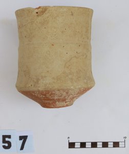
Stratum 57 in the eastern part of the trench abuts the subsoil in the southern end. Here, a small goblet-like ceramic vessel was found, again with the characteristic cranked body shape close to its bottom (Fig. 1).
In the eastern part the same layer continued with Strata 58, 59 and 60. An accumulation of small boulders was encountered here as well as fragments of a storage pit, stone tools, a fragment of a pan with a low rim and a spindle whorl made of clay with double conical shape decorated with circular grooves. Close to the northern section we uncovered a sequence of burned layers alternating with loess. It was probably used as a fireplace for a long period of time. An iron tool, probably a knife or even a sickle, was unearthed in this place.
After removing Stratum 60, almost on the subsoil, a very interesting stone mortar (Fig. 2) was found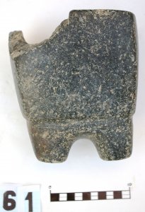 .
.
More specifically it was a fragment that showed the shape of the whole vessel. It was made of dark grey almost black stone with a highly polished outer surface. This mortar was 18 cm high, including four feet (two of which survived). The diameter of each foot was 3.3 – 3.4 cm, and the thickness of the vessel varied between 3.1 cm in the lower part and 1.7 cm at the rim. This mortar no doubt had a cultic function, but it is very difficult to say something more concrete at the present state of research. Parallels for such a mortar can be found among the finds form sites of Talashkan I and Qyzylcha VI. In the same stratum (No. 61) several shards of painted ware were unearthed (Fig. 3)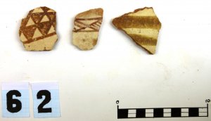
, which places the origin of the settlement of Jandavlattepa and its initial period at the turn of Late Bronze and Early Iron Age. Thanks to the completion of the strata-graphic trench we can summarize that the site of Jandavlattepa was inhabited for at least fifteen centuries and could provide important archaeological data for the Early Iron Age, Achaemenid, Graeco-Bactrian, Kushan and Kushano-Sassanian periods.
Sector 20 – “The Citadel” (Fig. 4)
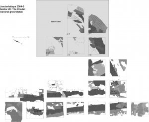
Our primary target on the citadel, as in both previous seasons, was to uncover as much of the architecture of the last period of occupation as possible. The shortage of time led us to open only five squares in the north-western part of the citadel’s summit. Among them, Squares 21D, 21O and 21P followed up the outer wall of the monumental building, more accurately its northern part. In the square 21D, the wall was disturbed by a large grave pit, in the Square 21O, by intensive erosion and by recent burrows. The characteristics of the wall correspond to the parts of the building we already knew. It consisted of poor quality, square mud-bricks (40-42 x 40-42 x 10 cm). Overall, it was preserved rather badly, with only several rows of bricks remaining. Earlier constructions were used as a substructure for the entire wall. This was well attested in the Square 21O, where a massive mud-brick structure was uncovered with several mud-bricks of the last building phase on the top. The situation in Square 21P brought to light a very interesting sequence of rebuilding. There were at least five walls with different orientations and various sizes of mud-bricks. Trying to resolve this complicated picture in the building development, we prolonged Square 21P by 3 meters to the west. In this part of the citadel we found more building phases than in the others, and only further excavations in the southern direction can help to shed more light on the situation. The youngest wall foundations belong to the same building phase as the constructions found in Squares 20O and 20Z, i.e. to the partition walls of the main building.
We supposed that we would find the remains of the inner disposition of the monumental building in two other squares: 21E and 21F. These squares were placed very close to the centre of the summit, notably to the newly placed primary topographical point. The prominent mullah-tomb was expected to be exactly in this place, and we were not surprised to find many layers of ashes extending from the centre of the citadel. An unfortunate accompanying feature of the main tomb was the presence of many simple graves as close to the centre as possible. These deceased persons probably received blessings for afterlife by being buried next to the mullah. In any case, the number of graves in Squares 21E and 21F disturbed the archaeological situation to a large degree. Amongst the 26 graves exca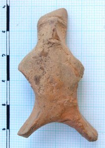 vated during the 2006 season on the Citadel, more than half were found in these two squares (14 graves). Unfortunately, due to this situation, we gained very little data on the inner disposition of the monumental building itself. The only exception was a small structure in the south-eastern part of Square 21F. This is probably the corner of a building, which has nothing in common with the monumental building. Next to this corner to the we
 st, another structure of special importance was found, a pavement or substructure made of small boulders.
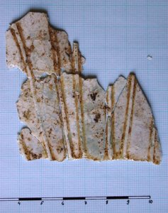
Concerning small finds, we were able to draw a typical picture of material culture of Kushano-Sasanian period; a rough terracotta figurine of a horseman, typical for nomadic people (Fig. 5), six bone hair pins, six clay spindle-whorls, four fragments of glass vessels, among them one very thin fragment decorated with applied fibres on its outer side (Fig. 6), several glass and stone beads and about ten fragments of iron tools and objects. Moreover, a dozen of bronze coins in bad state of preservation were found. All of them are datable to the Kushano-Sasanian period. This brief description should be understood as a preliminary report. The results of this excavation and also of all previous seasons will be included in the full report. The book Jandavlattepa I - The Excavations Report for Seasons 2002-2006 is currently being prepared.
List of illustrations:
Fig. 1: Goblet-like ceramic vessel with characteristic cranked body shape close to its bottom, Sector 2a, Stratum 57.
Fig. 2: Stone mortar, Sector 2a, Stratum 61.
Fig. 3: Painted ware of the Early Iron Age (period Kuchuk Ia.), Sector 2A, Stratum 61.
Fig. 4: Ground plan of Sector 20, the Citadel, seasons 2004-2006.
Fig. 5: Terracotta figurine of a horseman, Sector 20.
Fig. 6: Fragment of a glass vessel, Sector 20.

 .
.


 vated during the 2006 season on the Citadel, more than half were found in these two squares (14 graves). Unfortunately, due to this situation, we gained very little data on the inner disposition of the monumental building itself. The only exception was a small structure in the south-eastern part of Square
  st, another structure of special importance was found, a pavement or substructure made of small boulders.
